Chennai's second airport
Why Chennai chose Parandur for its second airport
Chennai's current airport cannot carry the region's long-term growth by itself. The official files show how four sites were compared, why Parandur came out ahead, and what tradeoffs now have to be solved on the ground.

Final airport capacity
100M/year
The long-term passenger target after all phases
Project area
5,368.93 acres
Land identified for the proposed airport
Sites compared
4
Parandur, Pannur, Thiruporur, and Padalam
Estimated cost
₹29,143.95 cr
Block cost estimate across four phases
The short version
The decision starts with capacity, then becomes a site-selection problem.
Parandur is being planned as Chennai's second airport, with a final target of 100 million passengers a year. The aviation argument is straightforward: Chennai's current airport has limited room to expand, while the city and its industrial belt are expected to keep growing.
The harder question was where to place that new capacity. Tamil Nadu and AAI compared Parandur, Pannur, Thiruporur, and Padalam. Parandur was finalized because it scored better on usable airspace, runway orientation, land availability, fewer man-made aviation obstacles than Pannur, lower stated displacement than Pannur, and access to the Chennai-Bengaluru Expressway corridor.
That does not make Parandur impact-free. The official boundary includes farmland, villages, roads, government land, and water bodies. The real story is therefore two-sided: why Parandur won the airport-location contest, and what the state must now prove on land, water, and resettlement.
Project map
See the airport footprint beside the alternative sites.
The red shape is the proposed airport boundary. The circular rings show the broader comparison areas for Parandur, Pannur, Thiruporur, and Padalam. Use the buttons to isolate each site.
What the maps reveal
The airport boundary
This sheet shows the boundary coordinates of the proposed airport footprint.
Open source sheet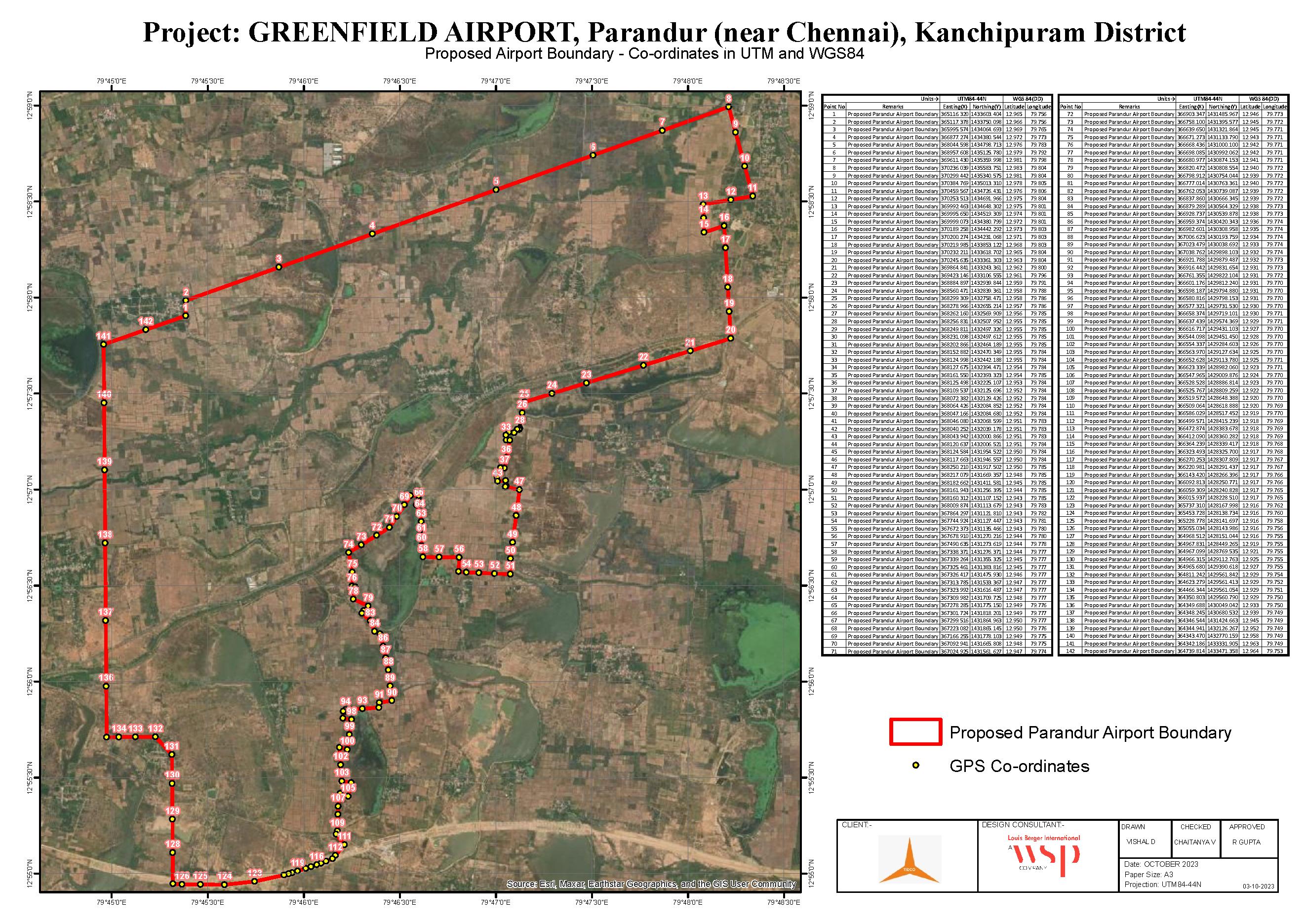
Land use
The same land looks different depending on the record.
Revenue records classify more than a quarter of the project area as water bodies and irrigation tanks. The drone survey records a smaller visible surface-water area. Both numbers matter: one describes legal and land-record classification; the other captures what was visible during the survey.
Revenue records
Drone survey
Why Parandur won
Parandur was not chosen because it had no problems. It was chosen because the other sites had bigger aviation problems.
The official comparison is blunt: Chennai's second airport needs clean airspace, a workable runway orientation, enough land for long-term expansion, and road access to the demand centres west of the city. On those tests, Parandur beat the other three options even though its land and water impacts remain serious.
Rejected early
Padalam
The documents place Padalam inside the restricted Tambaram Local Flying area controlled by the Indian Air Force. They also flag the Chengalpattu firing range nearby. That makes it a poor airport site before land or cost is even considered.
Operationally constrained
Thiruporur
Thiruporur sits close to the Tambaram restricted flying area, with the Chengalpattu firing range to the west and Kalpakkam nuclear plant constraints to the south. The report says the practical runway orientation would conflict more with Chennai airport traffic.
Feasible but weaker
Pannur
Pannur survived the first screening, but the documents identify several Extra High Tension towers and operating industries around the site. They also say Pannur would displace more families than Parandur and may need additional land for navigation aids.
Finalized
Parandur
Parandur had the strongest package in the official comparison: better fit for the preferred 07/25 runway orientation, fewer man-made aviation obstacles than Pannur, lower stated displacement than Pannur, large contiguous land availability, and stronger access to the Chennai-Bengaluru Expressway corridor.
Runway logic
The documents say the preferred orientation is 07/25, parallel to Chennai airport's main runway. Padalam and Thiruporur were weaker because their practical orientation created greater conflict with existing Chennai airport traffic.
Obstacle logic
Pannur was feasible, but not clean. The reports point to EHT towers, operating industries, and likely additional land needs for navigation aids. Parandur had fewer man-made aviation obstacles in the official reading.
Access logic
Parandur sits closer to the Chennai-Bengaluru Expressway corridor, which strengthens the case for passenger access, cargo movement, and future airport-linked development west of Chennai.
Buildout
The airport is designed to grow in four waves.
The first phase is planned for 20 million passengers a year. The fourth phase takes the airport to the 100 million passenger target.
2029-2035
Phase 1
20 million passengers
2036-2042
Phase 2
50 million cumulative
2043-2046
Phase 3
70 million cumulative
2047-2052
Phase 4
100 million cumulative
Villages and water
The project boundary cuts through a lived landscape.
The report says around 1,005 families are likely to be affected. It also identifies existing water channels crossing the project area and proposes to redevelop Nelvoy Eri as a storage tank. In plain terms: the airport can only work if the land and water plan works.
Villages listed in the project table
Timeline
How Parandur moved from option to priority project.
Select a date to follow the project from site screening to the current fast-track phase.

Mar 2026 / Fast track
Tamil Nadu declares Parandur airport a special project
March reporting said the state notified the airport as a special project under the Tamil Nadu Land Consolidation framework, raising the stakes around water bodies and land conversion.
The real test is execution.
The documents make a strong aviation case for Parandur: more capacity, a large site, better long-term planning, and a cleaner runway orientation than some alternatives. But the same documents show why this project cannot be judged only as transport infrastructure.
For residents, farmers, planners, and anyone downstream of the water system, the questions are more practical: who moves, who is compensated, where the water goes, how flood risk changes, and whether the replacement drainage plan performs in a real monsoon.
Source
Primary document set
This article is based on the OpenCity package for the Chennai Greenfield Airport at Parandur.
OpenCity source URL